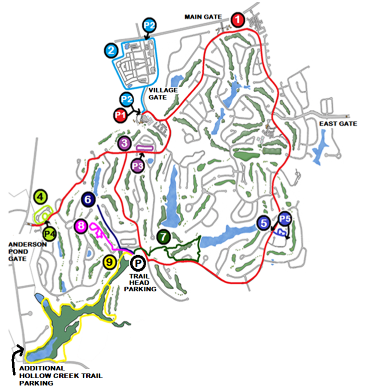
WOODSIDE TRAIL WALKER
  • Home
  • Past Events
  • Future Events
  • News
  • Photos
  • Maps
  • Contact

MAPS


Woodside Walking Path and Trails System

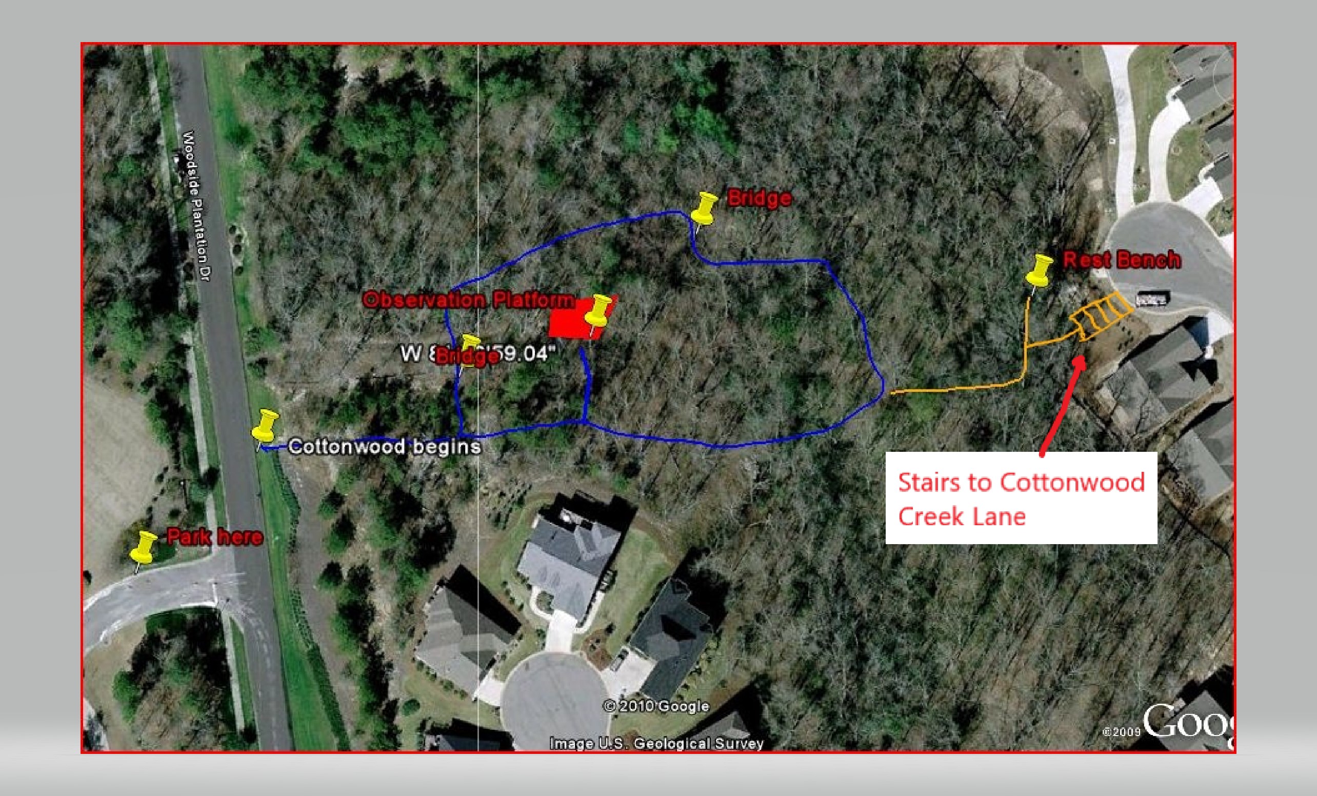
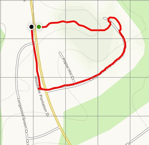
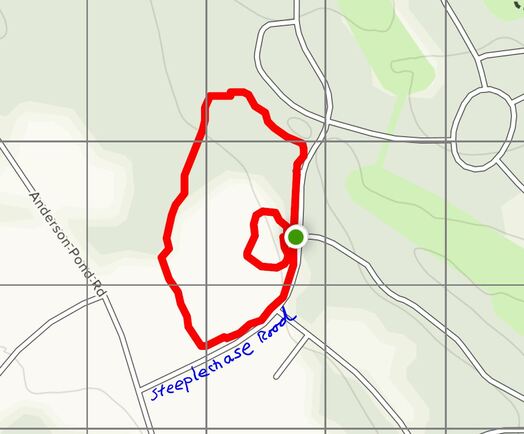
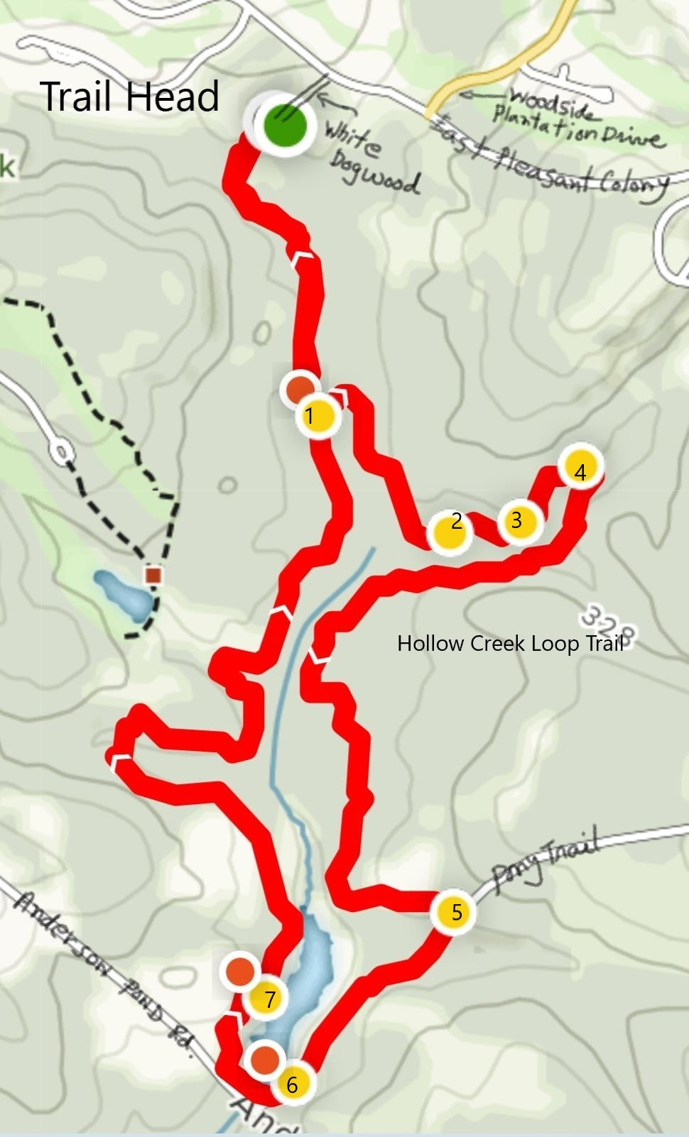
There are many opportunities for walking and hiking in Woodside. This two page overview map and guide locate the nine walking trails within or near  Woodside. All trails are well marked with blue paint and directional signs, but for specific hikes, you may want to take along the more detailed maps listed  below the two page overview. The Woodside Trail Group organizes hikes on these trails from time to time. Attending one of these hikes provides  a great opportunity to become more familiar with Woodside’s trails. . 
Picture
Picture

Nature Trails & the Hollow Creek Reserve.

The Mill Road and Azalea Trail System

Picture
  1. Azalea trail skirts Zoeller Golf hole 11
  2. Junction Hollow Creek and Azalea trail
  3. Hollow creek trail continues toward Anderson Pond Dam
  4. Mill Road trail meets Azalea trail​
Access
​Parking for this trail system is from the trail head parking area located on the road
leading to the Reserve Club’s maintenance area. This road is located at the crosswalk
near the T junction of Woodside Plantation Drive and East Pleasant Colony and West Pleasant Colony. A sign at the corner of West Pleasant Colony and the maintenance road and another sign
further along the maintenance road both point to the parking area.

​Trail System Description
From the parking area follow the sign pointing up the hill into the wooded area above
the parking area. At the next sign turn left and follow the blue blazes. The Mill Road, Azalea and HollowCreek trails follow a common path along White Dogwood and enter a few feet of
wooded area before the Mill Road Trail goes right while the Azalea and Hollow Creek
trails proceed straight ahead. The area is well signed.
As you walk along the Mill Road trail you may see wild life in the adjacent Hollow Creek
Preservation area. The path is wide for 0.5 miles and then becomes a single track as it
turns sharply left. The trail passes below the dam holding back Cunning Lake and then
has a very nice section that follows along a stream and over a small bridge to eventually
cross beneath the power line to join the second loop of the Azalea trail. The total
distance is about 0.75 miles
You can also access the Azalea trail by going straight forward and over a substantial
bridge used by hikers and golf course maintenance vehicles until you get to a signed
point where you make a right turn to access the first loop of the Azalea trail. If you turn
left here you will join the Hollow Creek trail on its way toward Anderson Pond dam.

The Azalea Trail consists of two loops more or less making a figure eight. You can walk
just one of these loops or both, either clockwise or counterclockwise. The two loops are
joined by a short section of trail that crosses a small stream via a bridge. The entire trail
from the parking area and back is about 1.5 miles with an elevation gain of about 300
feet. The area is completely wooded and provides a nice walk even in the heat of the
summer. On the first loop there are good hills to climb no matter whether you hike it
clockwise or counter clockwise! In the spring there is a nice display of native [Piedmont]
azaleas on both sides of the stream – hence the trail’s name.
You can see from the map that you can use this trail system in many ways to make a
circular hike. A popular way is to use the Mill Road trail to join the second loop of the
Azalea trail; turn right at the juncture proceeding around the second loop to where it
joins the first loop. Turn right here and proceed around the second loop to the point
where it joins the Hollow Creek trail and then over the bridge and back to the parking
lot – a total of 2.75 miles with some good hills to keep you in shape! For an easier hike
start out the same way but turn left at the junction of the Mill Road and Azalea trail and
follow along the power line to the junction of the trail with the Hollow Creek trail and
hence to the parking lot – a total of 1.5 miles with no hills.
Of course, there are many other combinations but no matter how you choose to walk
this trail system you are in for a treat!

Oakman Trail (2.1 miles)

Picture
Waypoints for Oakman Trail Map (see pictures below)
 1. Trail head parking
2. “Loop Begins” sign 
3. Trail joins cart path proceeding to Woodside Plantation Drive
4. Turn left and proceed to Oakman Lake dam

​Access Point
​
Parking for the Oakman Trail is from the trail head parking area located on the road leading to the Reserve Club’s maintenance area. This road is located near the T junction of Woodside Plantation Drive and East & West Pleasant Colony. A sign at the corner of West Pleasant Colony and the maintenance shed road and another sign further along the road both point to the parking area.

Trail Description
From the parking area follow the sign pointing up the hill into the wooded area above the parking area. At the next sign turn right and follow the signs and blazes to West Pleasant Colony. Cross the road and turn right along the sidewalk for about 200 feet, then turn left toward the rest room above hole 9 of the Reserve golf course. There is a short area here where the trail shares the golf course cart path. Watch for golfers on the T box and do not proceed unless it is safe to do so! After passing the rest room the trail turns right finally entering the wooded area between the fifth and sixth holes of the golf course. This is a nice area of mixed hardwoods. After crossing a bridge, you will come to sign saying “Loop Begins”. At this point you can turn right to follow the trail counter clockwise or left to go in a clockwise direction. Either direction offers the same views but from a very different perspective and, of course, they end up back at this sign. In this description the loop is walked in a counter clockwise direction.
Proceeding along the route you will soon cross a picturesque zig-zag bridge. Beautiful yellow flowers fill the area under the bridge in the spring. Proceeding you will soon join an asphalt path behind hole 6. Again, please watch for golfers and do not proceed until it is safe to do so. Soon you will join the cart path between holes 6 and 7 and proceed to Woodside Plantation Drive. Cross the road and turn left along the sidewalk along Woodside Plantation Drive. This is a very pleasant area of sidewalk, well separated from the road. After about 0.2 miles the trail recrosses Woodside Plantation Drive and goes back into a wooded area that also serves as an access path to Oakman lake. There are nice views of the lake from the dam. Crossing the dam be aware that you are once again sharing the path with golf carts, but in this area there is no danger from stray golf balls! Leaving the asphalt path, you will once more enter a nice area of mixed hardwoods leading back to the “loop begins” sign. From there turn right and follow the trail back to the trail head parking area. The total distance is 2.1 miles.

Picture
Oakman Lake from the Dam
Picture
The Zig-Zag Bridge
Picture
Zig-Zag Spring Flowers

Creek Walk

Picture
Access
The Creek walk is a short 0.5 mile neighborhood walk. The trail entrance is clearly marked on Woodside Plantation Drive just north of its intersection with Longwood Green Court. If accessing the trail by car, please park on Longwood Green Court rather than Woodside Plantation Drive.
Trail Description
 
The Creek trail is a short 0.5 mile neighborhood walk. The trail entrance is clearly marked on Woodside Plantation Drive just north of its intersection with Longwood Green Court. If using this access point, please park on Longwood Green Court rather than Woodside Plantation Drive. A second access point is by a set of stairs in the circle at the end of Cottonwood Lane. The trail is blue blazed.
The circular walk is fairly flat and follows the Cottonwood Creek steam bed, crossing it in several places on wooden bridges. There is a bog bridge thru the lower lying areas. There are two observation platforms where seating is provided. A family of deer uses this area as their home base and if you sit quietly you may often observe them. The area is completely shaded and makes a nice cool retreat on a hot summer day.
The Creek Walk, Cottonwood Lane, and a piece of Woodside Plantation Drive can also be used to make a nice 0.6-mile circular walk around this neighborhood. The map below illustrates the route.
Picture


​The Meadows Loop Trail

Access
The trail is located in front of the pagoda in the “Meadows” park. Or if you are walking in the neighborhood, follow the steeplechase sidewalk toward the Anderson Pond gate and then turn right at the Woodside property perimeter fence. Easy to find; pleasant for a comfortable romp.
Trail Description
This is a neighborhood trail in Woodside! It is a 0.6-mile loop trail in The Meadows. The trail is a very flat dirt path suitable for an easy short stroll. You can add another 0.2 miles by walking around the “Meadows” park side walk. Of course, for a longer walk you can go around a couple of more times. The trail is not blazed but it is easy to follow. Try it – you’ll like it!
Picture

Hollow Creek Loop Trail

Picture

Way Points for Hollow Creek Loop Trail Map
1 -- Loop Begins; turn left to follow in clockwise direction or go straight ahead to follow in a counter clockwise direction.
2 to 3 -- Rerouting around T boxes for holes 9 of the Zoeller golf course
4 – Arrive at golf course access road. Turn right go 50 feet then right again
5 – Turn right on road formerly known as Pony Trail
6 – After gate turn right and go over Anderson Pond dam
7 – Anderson Pond fishing platform
​Access Points
There are two access points to the Hollow Creek Trail [HCT]. The trail head parking area within the gated community is located on the road leading to the Reserve Club’s maintenance area. This road is located near the T junction of Woodside Plantation Drive and East & West Pleasant Colony. A sign at the corner of West Pleasant Colony and the maintenance shed road and another sign further along the road both point to the parking area. The other access point is outside the gated community. It is from a parking area located just north of the dam on Anderson Pond Road. To get there exit the gated community Woodside’s Anderson Pond gate, turn left and go along Anderson Pond Road for about 1 mile. The parking area will be on the left. If you go over the bridge over Hollow Creek you have gone too far. This access point is about half way from the trail head.
 At a later time, we hope to establish an access point somewhere in this area for residents of the Hollow Creek community.

​Trail Description
The following is a quote from the Woodside Developer’s web site:
"Hollow Creek Land Preservation, Inc. was established in 2007 by the developer of Woodside to perpetually preserve and protect approximately 110 acres of natural woodland and wetland area adjacent to Woodside, known as Hollow Creek Nature Preserve."   (See https://woodsidecommunities.com/nature-conservation/ )

The Hollow Creek Trail basically follows the perimeter of the Hollow Creek Nature Preserve. It offers a 4.8-mile hike through mainly wooded areas with some nice views of the Zoeller golf course, streams that flow in this area, and of Anderson Pond. 
Distances in this description are measured from the trail head. Follow the blue blazes and metal directional signs. Leaving the trail head, the trail proceeds for about 100 yards where it intersects with the Mill Road Trail. Signs at this junction clearly show the way to each trail. The HCT proceeds straight ahead. You will soon join a path coming in on your left from the Reserve Club maintenance shed. Follow this path over the wooden bridges and then turn left at the directional arrow. The trail parallels the golf cart path between holes 10 & 11 of the Zoeller golf course for a few hundred feet and soon enters a wooded area. After 0.5 miles the trail joins the golf cart path between holes 7 & 8. This is where the loop begins [Waypoint 1]. You can do the loop in either a clockwise or counter clockwise direction. The following description follows the trail in a clockwise direction.
 Begin the loop by turning left to go over the pedestrian bridges. Please note that there is both a golf cart bridge and a set of pedestrian bridges over Hollow Creek. Do not use the golf cart bridge! After crossing the bridges, you will find yourself at the base of the T boxes for hole 8. Turn right and follow the trail as it skirts along the edge of the woods for about 100 feet and then turns right again to enter into a nicely wooded area. After 1.0 miles [Waypoint 3] the trail will briefly leave the wooded area to come out at the base of the T boxes for hole 9. Follow the trail as it skirts along the base of these T boxes for about 150 feet before once more entering the woods. After 1.1 miles you will arrive at the access road that was used to construct holes 8 and 9 [Waypoint 4]. Turn right here and after 50 feet turn right again into the woods. From here on you will leave the golf course behind and enjoy a very nice walk through the woods for the next 1.2 miles. Please note that this area is rather remote and mobile phone service is not always available. Best to go with a friend!
At mile 2.3 the trail joins a very nice country dirt road that shows up on some maps as Pony Trail, even though it is entirely on Woodside property. Turn right on this road [Waypoint 5] and follow it to Waypoint 6, at which point you will have travelled 2.6 miles from the trail head. After the old iron gate turn right and follow the trail across the Anderson Pond dam. If you feel uneasy about crossing on the dam you can go out to Anderson Pond Road and cross the Hollow Creek stream on the automobile bridge and then return to the trail. There are some very nice views of Anderson Pond from the dam area. At mile 2.8 you will see a trail coming in on your left – this goes to the Hollow Creek Trail access point from Anderson Pond Road. Parking is available here. Keep right along the main trail. At mile 2.9 you can take a break on the fishing platform on Anderson Pond [Waypoint 7].
After leaving the platform you will enjoy a very nice area of mature pines and hardwoods for the next for the next 1.4 miles when you will end back at the starting point of the loop. At this point you will have walked 4.3 miles from the trail head. Follow the trail signs back to the trail head. The entire distance will be 4.8 miles.
For more information on this route you can use the following link to “All Trails” to see some pictures and elevation changes as you proceed around the trail.
 (See https://www.alltrails.com/explore/recording/recording-apr-10-12-29-pm-a486cd0 )

Slide Show

Check here to see an overview of some of our trail group activities.
Powered by Create your own unique website with customizable templates.
  • Home
  • Past Events
  • Future Events
  • News
  • Photos
  • Maps
  • Contact